
2023.05.11
The importance of data utilization and analysis in understanding cities has long been recognized. However, it is not enough to simply rely on data alone to improve the urban environment. The challenge lies in determining what data to use, how to analyze it, and how to translate it into meaningful change. Implementing data-driven practices can be particularly challenging. To gain insights into this matter, we spoke with Stephen Law from The Alan Turing Institute, who was formerly associated with Space Syntax and has extensive experience in various projects.
Index
--Stephen, you are currently affiliated with University College London and The Alan Turing Institute. What sparked your interest in urban analysis?
Stephen Law (Stephen): I developed an interest in cities due to the stark contrast between my upbringing in Hong Kong and my university experience in Canada. Life in the Canadian suburbs was vastly different from the densely populated city of Hong Kong. In the suburbs, there were limited opportunities to interact with people, and it would take me a significant amount of time to reach any destination. I remember it would take me 20 minutes just to reach the nearest convenience store by bicycle. In contrast, Hong Kong offers a vibrant urban environment with high-rise apartments and convenient access to various amenities. People in Hong Kong would often ask each other which floor they lived on rather than referring to specific addresses or areas. I could easily walk for 5-10 minutes to buy anything I needed and meet multiple friends throughout the day.
--It seems like both environments presented their own challenges.
Stephen: Indeed, I recognized the issues present in both settings, and this piqued my interest in urban analysis. I wondered if it would be possible to create a city that strikes a balance between the characteristics of Hong Kong and Canada. Copenhagen, for instance, serves as an example of such a city. While I initially pursued a degree in economics at a Canadian university, my passion for urban planning and design led me to pursue a Ph.D. in the field, focusing on spatial network analysis and related areas of research.
--So, you began actively working in the field of urban analysis.
Stephen: That's correct. I subsequently gained experience working for two urban consulting firms—AECOM, a large multidisciplinary engineering firm, and Space Syntax. My tenure at Space Syntax spanned over 10 years, during which I contributed to a wide range of projects.

Stephen Law
Stephen Law is a Fellow of The Alan Turing Institute. He pursued studies in economics in Canada and urban design in England. He gained valuable experience working at Space Syntax, a London-based consulting firm renowned for its scientific approach to architecture and urban design. Stephen completed his Ph.D. at UCL, and his research now centers around exploring the economic value associated with urban design.
--Can you share any projects that have left a lasting impression on you?
Stephen: One project that stands out is the Elephant & Castle Crossing in London. This project involved addressing the challenges posed by two large roundabouts that were known to be dangerous intersections. Pedestrians had to navigate underpasses to avoid these intersections. Our team worked on transforming the intersection and developing a master plan for the area, which significantly improved traffic flow. We conducted extensive analyses throughout the project, and I still remember the challenges we faced in convincing the London Transport Authority and the Borough of Southwark.
--What was your role in the project?
Stephen: During that time, street cameras were not yet prevalent, so we had to physically observe how people were walking and using the space. We conducted various modeling exercises to estimate the increase in pedestrian traffic if the intersection were eliminated. At that time, the intersection acted as a barrier within the city, and we believed that reconfiguring it would increase overall usage and positively impact the surrounding area. Initially, we proposed reimagining the crosswalk as a public space, creating a 10-meter wide pedestrian crossing. We even built a mockup of the crosswalk and invited the client to walk through it to experience the potential changes firsthand.
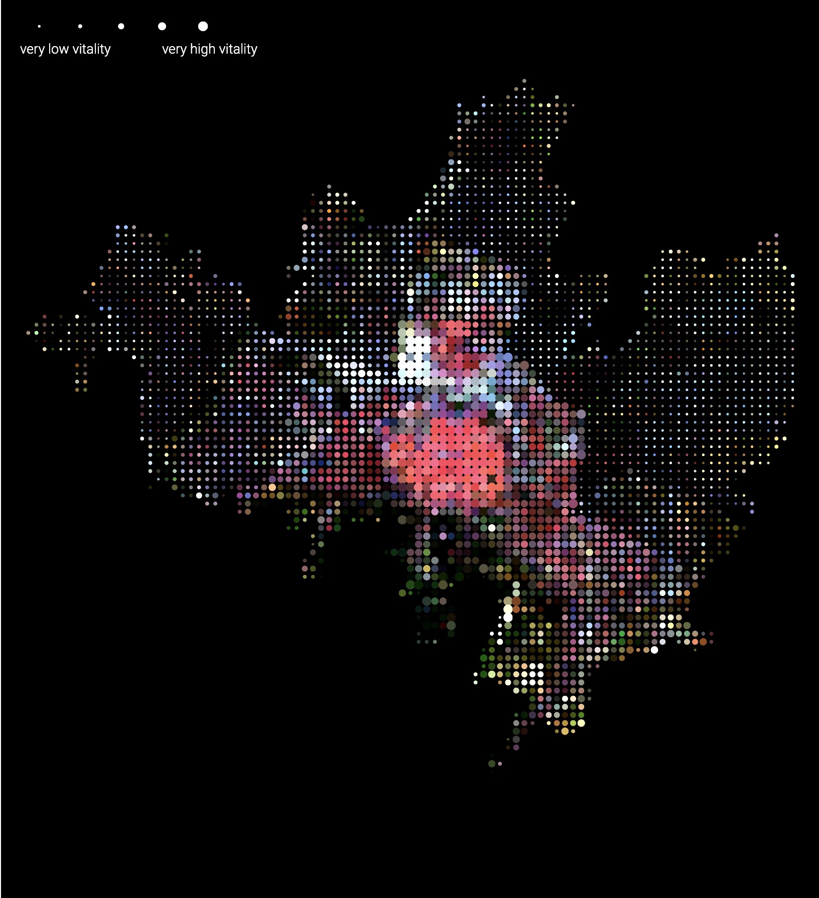 Urban vitality of Bologna as predicted from Satellite imagery. Courtesy of Nokia Bell Labs Jane Jacob in the Sky project
--Do you perceive a gap between your research and the practical application of methods such as analysis and image analysis in the business world?
Stephen: I believe the main gap lies in communication. Initiating public space reforms, like the one I mentioned earlier, involves significant costs and necessitates a consensus-building process with clients. Merely articulating the mutual benefits is insufficient. Instead, I find that utilizing a communication language that relies on visuals and intuitively demonstrates the impacts of measures and analysis is effective. If we can discover a way to communicate value intuitively, we can engage not only with local governments but also with residents and developers.
--Indeed, communication becomes more intricate in a complex environment like a city, where numerous stakeholders are involved. I, too, struggle with breaking down the macro-level benefits. For instance, while alleviating traffic congestion is advantageous for the city as a whole, it is challenging to visualize the specific benefits that developers, local governments, and transportation agencies will derive.
Stephen: I am aware that cost-benefit analysis is often utilized in fields such as transportation planning. However, I believe it is perilous to reduce everything to monetary indicators alone. For instance, how do we assign a value to the serendipitous encounter of meeting a friend on a street corner in Tokyo and engaging in a conversation? It is indeed a difficult task. Furthermore, providing value to one group may inadvertently impede the fairness of another. While economic indicators facilitate discussions among individuals in different positions, we must always exercise caution to avoid overlooking important aspects.
 Verification of a project carried out at Elephant & Castle Crossing. IMAGE COURTESY OF SPACE SYNTAX
--In recent years, carbon dioxide emissions have gained increasing recognition as a valid indicator, second only to economic indicators. While this is desirable and presents an opportunity to restructure cities with a long-term perspective, shouldn't the parameters for evaluating cities be more diverse? However, there are "classes" of indicators, and even if we increase the number of parameters, people often tend to focus primarily on economic and carbon indicators, relegating other parameters to a secondary position.
Stephen: Evaluating cultural values poses challenges, particularly as arts and humanities budgets have been reduced in the UK as well. Cities can be evaluated as sources of creativity and diversity, as Richard Florida discussed in his concept of the "creative class." Moreover, in the modern era, the notion of "beauty" seems to have been neglected as a criterion for evaluating cities. However, studies such as "Happiness is Greater in More Scenic Locations" by Chanuki Illushka Seresinhe et al. suggest a connection between people's happiness and the beauty of the landscape.
--I strongly believe in the value of creativity and feel that we should strive to share it with more people. Who are some companies or researchers that you are currently interested in?
Stephen: I am interested in a researcher named Michael Schissel, who teaches at the University of Copenhagen and focuses on bicycles in his research. Many of his papers revolve around network optimization and expanding the bicycle network. Copenhagen is renowned as a bike-friendly city, and he meticulously analyzes every detail. Not only does he write papers and create tools, but he also collaborates on projects with the government, aiming to develop new transportation models. Another exciting researcher is Geoff Boeing from USC, who developed the street network modeling software "OSMnx." The tools he has created are democratizing the process of analyzing cities.
--Interesting. Stephen, how do you envision the future changes in cities?
Stephen: I cannot predict exactly what cities will look like in 10 years, but climate change will significantly impact urban mobility. For example, the need to prioritize cooler streets over the shortest routes may reshape transportation perspectives, and new modes of transportation may emerge. Additionally, if autonomous driving becomes widespread, parking lots may disappear, allowing the use of these spaces for other purposes and transforming the urban landscape. In any case, predicting the cities of the future is challenging as they will undergo transformations influenced by various factors, including climate change.
 The Elizabeth House project revealed the lack of community connectivity by charting pedestrian movement. IMAGE COURTESY OF SPACE SYNTAX
Stephen's stories about urban metrics are always fascinating. I first came across his work through his paper "Take a Look Around: Using Street View and Satellite Images to Estimate House Prices" which explored the potential of satellite and street view imagery in quantifying landscape values and prices. We started interacting on Twitter and have since developed a strong friendship.
Our conversations often revolve around the class of indicators. When considering a city, it is crucial to go beyond catchy and prominent indicators such as economic benefits and carbon emissions' environmental impact. We should also consider indicators that reflect the well-being and biodiversity provided by the urban landscape.
However, personally, I believe that we can drive the long-term optimization of cities by leveraging strong indicators like carbon. For instance, it is estimated that 40% of urban space is currently occupied by transportation infrastructure, such as roads and parking lots. This means a significant portion of urban space is allocated to areas that hold little or no meaning for residents. By optimizing traffic with a focus on carbon emissions, we have the potential to transform the area occupied by roads and parking lots. In the future, parking lots could be transformed into parks, and roads could be repurposed as coffee shops and bars.
While many people associate carbon solely with reducing environmental impact, there is an opportunity to enhance cultural diversity by optimizing urban space based on carbon indicators. There is room not only to diversify the range of urban indicators but also to explore new ways of utilizing and perceiving them.
Interview conducted by Soma Suzuki (Spatial Pleasure)
Edited and written by Toshihiro Ishigami